Introduction
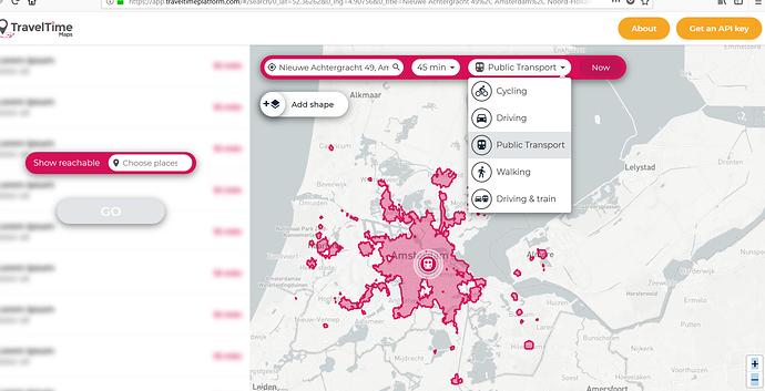
The travel times tool can be used to inform people about what areas lie within a certain travel time for a particular spot.
Use cases include: reducing city centre crowding by encouraging people to live outside the city, showing them good commuting locations
Example of what it would look like
Participants
- Lead: Amsterdam
- Support: Gent
- Testing partners: -
Anyone is free to join this working group!
Goals
This Challenge Working Group needs to accomplish the following:
- Define working group: Engage the right people in the discussion
- Common architecture: Assess the available data and technical architecture of involved solution development partners, implementation opportunities in the Living Labs, and what would be reasonable architecture to deploy the solutions on. Template will be provided by the University of Bradford.
- Research: Researches existing Open Source solutions or libraries that can be adapted and built on.
- Commit: Ensure internal support in each partner to continue to the solution definition phase.
Once complete, this group will graduate to a solution working group.
Next steps
- April 11: Complete the list of working group members (see below) before
- April 16: Complete common architecture inventory
- April 16-20: Working group teleconference for week of April
- April 26: Update consortium on progress during teleconference
- May 10: Complete research on existing solutions or libraries
- May 24: Formal commitment from all partners to continue to solution definition phase
Working group members
City of Amsterdam
- Problem owner: None yet
- Product owner: None yet
- Technical team members: None yet
Digipolis Ghent
- Problem owner: None yet
- Product owner: None yet
- Technical team members: None yet
Testing partners
- None yet
Other to do’s
- …
- …
- …
Please keep this post updated. Everyone can edit this Wiki post.


